Fitxategi:Corrientes-oceanicas-en.svg
Nabigaziora joan
Bilaketara joan

SVG fitxategi honen PNG aurreikuspenaren tamaina: 800 × 404 pixel. Bestelako bereizmenak: 320 × 162 pixel | 640 × 323 pixel | 1.024 × 517 pixel | 1.280 × 647 pixel | 2.560 × 1.293 pixel | 976 × 493 pixel.
Jatorrizko fitxategia (SVG fitxategia, nominaldi 976 × 493 pixel, fitxategiaren tamaina: 1,7 MB)
Laburpena
| Deskribapena |
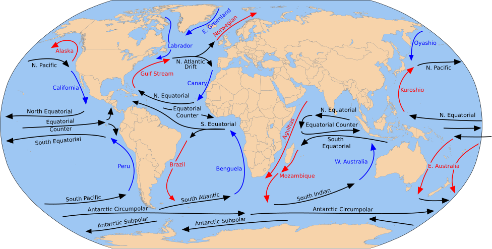
English: A detailed Robinson-projection SVG map with grouping enabled to connect all non-contiguous parts of a country's territory for easy colouring. Smaller countries can also be represented by larger circles to show their data easier. A thorough description of use and other instructions relating to can be found on the instruction page. |
| Data | (UTC) |
| Jatorria |
Fitxategi hau hemendik eratorria izan da: Blank map of the world (Robinson projection) (10E).svg: Fitxategi hau hemendik eratorria izan da: Corrientes-oceanicas.png: |
| Egilea |
|
_(10E).svg)
SVG fitxategi honek Inkscape edo Adobe Illustrator bezalako SVG editore bat erabiliz erraz itzul daitekeen barneratutako testua du. Argibide gehiago. Nahi izanez gero, fitxategia jaitsi eta testu editore bat erabiliz ere itzul dezakezu. |
Lizentzia
Nik, lan honen egileak, argitaratzen dut ondorengo lizentzia pean:
| Nik, lan honen egile eskubideen jabeak, lan hau domeinu publikoan jartzen dut. Mundu osoan du eragina honek. Estatu batzuetan beharbada hori ez da legez posible izango. Halakoetan: Edonori ematen diot lan hau edozertarako erabiltzeko eskubidea, inolako baldintzarik gabe, legeak nahitaez ezarritako baldintzak izan ezik. |
Jatorrizko igoera erregistroa
This image is a derivative work of the following images:
- File:Blank map of the world (Robinson projection) (10E).svg licensed with PD-self
- 2011-05-16T04:18:31Z Milenioscuro 3100x1600 (2087786 Bytes) {{Information |Description={{en|1=A detailed Robinson-projection [[Help:SVG|SVG]] map with grouping enabled to connect all non-contiguous parts of a country's territory for easy colouring. Smaller countries can also be repres
Uploaded with derivativeFX
Fitxategiaren historia
Data/orduan klik egin fitxategiak orduan zuen itxura ikusteko.
| Data/Ordua | Iruditxoa | Neurriak | Erabiltzailea | Iruzkina | |
|---|---|---|---|---|---|
| oraingoa | 17:26, 5 otsaila 2025 | | 976 × 493 (1,7 MB) | wikimediacommons>Mastersun25 | update Karabakh |
Fitxategiaren erabilera
Fitxategi hau darabil ondorengo orri honek: